37 at 37

March 11, 2020
Jerez enroute to Seville
22 hours of flights and airports, three movies, and over 4500 miles in the air, and we’re finally in Andalusia. Checking with my gps, however, discloses that we’re at the 37 th parallel, 3737 miles from home. And really out of touch with much news from the United States. I hadn’t realized that EU privacy laws, which changed last May, disabled most American news sources. I can get headlines, but when I click my usual sources–Trib/NYT/Wall Street Journal, and Pantagraph–I get a notice that they are banned from delivering content. And ESPN switches to the Spanish/European edition.

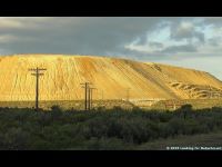
Perhaps it’s just as well that we are enjoying where we are, which seems far indeed. We left Jerez earlier today for Seville, having seen the three biggest sites in Jerez, a city of 200,000 that has its roots in Phoenician, Roman, Muslim, Spanish cultures and histories. The Phoenicians left nothing except stories about Hannibal and Carthage, and vineyards. The legacy was one of the main crops of al-Andalusia (named for the Muslim influence, which lasted from 711 until the 13 th century, when Alfonso the Wise, so-named because he knew at least three languages, which made him wise at the time, reconquered this part of Spain from the Muslims). The soil apparently is excellent for a white grape that lends itself to sherry, and on the hill that commands the city, one of the wine bodegas is Gonzalez Byass, makers of Tio Pepe, the largest selling brand, and the most visited vineyard in Spain.

I did my part, touring the facility, which included sampling four varieties. Mr. Gonzalez was a banker turned wine-grower (at 23) who took on Mr. Byass, an English financier, as a partner, and the two families, now in the sixth generation, still run the company. It owns and sells a variety of wines around the globe, including Chilean, and some brandies. I was a little surprised to learn that sherries do not get packaged by year because it is a blended mixture, and can age up to 20 years—the older, the sweeter—like people, n’est ce pas?

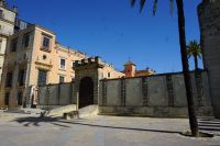
The second edifice on the hill that overlooks the city was the symbol of political power—the Alcazar. Apparently two Muslim dynasties ruled the 
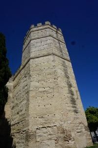
city, and each was responsible for establishing part of the Alcazar (if it starts with an al—it’s probably Islamic). The Alcazar was residence/fortress of th
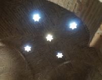
e rulers. Much of it is restored—the horseshoe archway, the three room baths—hot, cold, and ablution—with star-like holes in the dome to remind the Muslims of their desert heritage, a small mosque (that became a chapel), and square ramparts and towers that proved the best views of the town. There’s also a garden and some pools, along with orange trees whose fragrance fills the air. The Alcazar became the residence of the mayor, one of whom built an 18th century baroque palace within it that somehow works with the Muslim architecture.

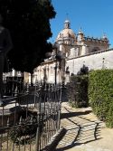
Across from the Alcazar, and built on the site of the Mosque (winners can do that) is the basilica, a huge cathedral in its second version. The tower from the first remained after (I think) an 
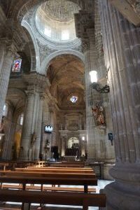
earthquake, and the rebuild was mostly gothic/baroque, two of my favorite church styles. Some of the altars and paintings came from convents and monasteries that were at one point or another confiscated. The main painting is a Zurbaran of a young Mary (late 16th century). When Pope John Paul II visited here in 1980, he elevated the cathedral to a basilica, meaning it’s the seat of the bishop.

The three main sites were within easy walking distance from our hotel—enshrining religion, political power, and money at the time. We’re now in Seville, about 90 miles away, with another interesting story to tell, beginning with the name of our hotel, which is how I’ll start tomorrow night’s blog.

“Ruined” by 4 Mayan Sites

January 5-6, 2020
We’ve spent the past two days exploring four more Mayan sites. Though the Mayans occupied the area for over 1000 years (roughly 200 BC until 1400 AD), and left over 1500 known cities, the five (counting Palenque) we visited spanned most of the entire period.

The biggest ruins in the Yucatan might well belong to those at Chichen Itza, or at least the most excavated and most visited. Up to 19,000 visitors a day arrive by the busload during peak season (last week), and it seemed like there were that many when we were leaving.  We got there shortly after the park opened at 800, so there were still a few spots left in the parking lot. That did not last long. I can understand the fascination with a site labeled as one of the seven wonders of the modern world.

Our hotel there had a main entrance that was part of a hacienda purchased by Edward Thompson, American vice consul in Merida, who was responsible for some of the early excavations—and the man who used his diplomatic pouch to secret a number of artifacts to the Harvard Peabody Museum. Harvard won a battle waged by the Mexican government to get the material returned. The Mexican supreme court ruled that the laws at the time were inadequate to protect the nation’s treasures, so Harvard could keep the items; in a gesture of gratitude, some of the materials were returned. Mr. Thompson himself was hounded out of Mexico, however, and the hacienda sold to archeologists who built cabins, one of which was occupied by Mr. & Mrs. Hoyt.

Like most of the excavated sites, only a small portion of any of the sites has been recovered or restored.  Given time, the jungle wins, or the cost of recovery is enormous. Coba, were we visited today, for example, spanned 40 square kilometers. Less than 15% is restored.

Chichen Itza is classic period—about 1000 AD—which means the buildings were architecturally and artistically at their peak. The city-state was one of the most dominant, controlling as it did, one of the ancient world’s most important products—salt–until drought and population pressure eroded its sway.

The pyramid is 42 meters high, one of the highest, built atop an earlier version which contained a tomb whose finery now graces the national museum. My favorite buildings, though, were the ball court, the largest known with a “hoop” about 15 feet off the ground (try and dunk that); a ritualistic altar with thousands of skull figures (the macabre idea borrowed apparently from the Toltecs in central Mexico; the popular but apocryphal story is that the losers were decapitated); the observatory (the Mayans, like most successful agricultural civilizations placed great emphasis on the rain god and were adept astronomers and astrologers; the construction of the observatory allowed stargazing even during the day); the temple of 1000 warriors, with a jaguar god atop, and 1000 pillars that for all the world looks like something borrowed from a Roman movie set; and, bless the Spanish, two buildings named by them, the “nunnery” and the “church,” older buildings with some of the best intact steles and bas-relief that we’ve seen.

Partly because of the crowds and the wear and tear, none of the buildings is readily accessible. That’s probably a good thing because the pyramid has 365 steps (the Mayans knew the days of the year). Carolyn is super impressed with any civilization that reveres jaguars. We did see two jaguar crossing signs on the way to Cancun.

Ek Balam, the jaguar city, was older (pre-classic period) and easily combined in one day with Chichen Itza. The site had an unusual rounded building and some excavated common folk housing—all ten feet per room—that we saw nowhere else. I liked the reconstructed Mayan “arch” at the gateway to the city, which was triangular. The road there was full of pilgrims, many on bicycles, heading to a Church of the Three Wise Men, since Monday, the day of the arrival of the three wise men, is the gift-giving day associated with Christmas in Mexico.

Today’s visits were to Coba and Tulum, two later (post classic; Tulum, in fact, lasting until the Spanish explorations, which was unusual for the Mayans). Coba, as mentioned, occupied 40 square kilometers, and even though only a small portion is excavated, those buildings are sufficiently scattered that we had a trishaw with a driver to take us around. Our guide noted that the workmanship deteriorated, but it was hard to tell in a city that had two ball courts (American and National League?), and a pyramid taller than the one at Chichen Itza (but unrestored).

The most stunning site was Tulum, settled for a long time, but come to prominence late—stunning because of its location on the coast. Apparently, it was sort of a customs station or duty-free shop for Mayans along the coast, protected by a wall on 3 sides and steep cliffs down to the ocean on the fourth side. Large iguanas willingly posed for pictures, but the buildings atop the hills—again, some of them resembling Roman ruins because of the pillars used to hold up a (no longer there) wooden roof. The most unusual of the gods was an upside-down man, facing west—the direction of the setting sun.

Given that the palaces of the Mayan rich were much nicer than the (mostly unexcavated) hovels of the poor, it’s fittingly ironic that our last night is being spent in Cancun, in one of those updated 21st century palaces.

Pre Mayan Mexico: land of the big heads

January 4, 2020
If you think—and some of you I know do—that I’ve got a big head, you should see some of the statues we’ve been looking at today.

They’re from the Olmec civilization, circa 1200-200 BC. You can find them in lots of places; we first did a year ago, at the National Archeological Museum in Mexico City. That’s really a great introduction to Mesoamerica because, as the nation’s major museum, it got first crack at most of the art (that didn’t wind up in Europe or the United States). There are, however, enough Mesoamerican artifacts to fill more than one museum.

Grandma meet grandma
Walker meet walker

For example, you can spend an afternoon in Villahermosa (literally, beautiful city), a town of some 700,000, the capital of the state of Tabasco (known in Mexico as the birthplace of President Amlo—not Tabasco sauce which is I recall a product of Louisiana imagination). Here, a very imaginative  poet conceived of moving the Olmec ruins from inaccessible La Venta to an accessible park in the city which housed a natural history museum, an aquarium, a planetarium, a zoo, and a host of other institutions, which now includes an archeological park of some 40 Olmec statues, altars, and plinths set in the lush jungle.

The enormous heads draw speculation on the transport of tons of stone because the Mesoamericans did not have wheels. And yet…basalt and sandstone in particular, with ten foot heads were transported (my favorite guess was using whale grease), paving the way, so archeologists argue, for the later Mayans, the bas-reliefs giving rise to later steles, and some of the art patterns repeated for the next 12-1500 years by their successors (and adopted by THEIR successors, the Aztecs, and their successors, contemporary Mexicans).

The Olmec area seems to have been in the Yucatán/Guatemala/Honduras jungles, and the artifacts in the park cover about 500 years, mostly from La Venta. I had to take pictures of Carolyn with the “Grandmother”, and myself with “The Walker,” but the most stunning items besides the big heads are the altars, usually with a man/bird/jaguar/crocodile half emerging from a cave (the underworld). The eagle carried the sun during the day (and is part of the Mexican flag), and the jaguar carried the sun through the netherworld at night.

From Villahermosa, our trek meant a short flight to Merida, capital of the Yucatan (and purportedly Mexico’s safest city) and then an hour and a half ride to Chichen Itza, where tomorrow we get the advanced course in all things Mayan.

Downhill and Backwards in Time to Palenque

January 3, 2020
We’re only 58 miles (as the crow flies) and 6200 feet lower than we were yesterday, but getting from the colonial charm of San Cristobal and its nearby Mayan descendants to the classical Maya ruins at Palenque was almost a six hour trip. Part of that was the descent which followed a lot of ridgelines, which meant curved type C roads (meaning usually not wide enough to pass, at least in theory); part of the delay was from topes—speed bumps. Our driver/guide said on one trip he counted the number, and it was 259, but that needs to be updated. The speed bumps not only replace stop lights and stop signs in towns as ways to slow traffic at important junctures (school crossings for example), but enterprising shopkeepers have them built up daily to encourage traffic to stop for bananas, the omni-present coke, or pollo (chicken), or gasoline or….

Part of the length of the trip came from a short side trip to Aqua Azul, a national park (meaning three toll booths) to view cascades on the local river that is known for its blue green water during the dry season (now) and its muddy turbulence during the rainy season.

It was worth the drive down through at least three ecosystems, starting with pine and ending with humid jungle (there are howler monkeys sharing the resort we’re at with us); Palenque has a well-deserved reputation as one of the top ruins in the Mayan period, and with reason.

While the settlement began about 100 BC, the heyday was during the reigns of King Pakal, his son, and grandson, in the 8th century (700-800 or so). Pakal was a successful warrior, and constructed buildings that were artistic monuments to his success. And he lived to be 80 years old, unheard of at the time, and was thought to possess magical powers because of a deformed leg.

The temples/tombs/palaces, which comprise the majority of the excavated sites (a small portion of the site) mark the architectural highlights of the classic Mayan period (700-900). The buildings are mostly pyramid shaped, towering probably 150 high, at one time embracing a city of maybe 100,000 people. There’s a tomb for Pakal, his official wife (the Red Queen, so named because of the cinnabar sprinkled on her), an unexcavated Jaguar temple (something like 20 temples have been excavated, or at least named; as I saw in Cambodia, left alone, the jungle always wins), and a huge palace with an underground stream forced to go through a narrow passage and thus speeded up to the point where it had enough pressure to supply the palace with running water.

I was really glad that we’d gone to Mexico City last year and visited the National Archeological Museum there, because some of the choice relics are there—in particular the jade death mask of Pakal. The highlight in the museum here is a replica of the sarcophagus of Pakal, a huge box with elaborate stone bas reliefs that have some of the best-known glyphs of the period.

Pakal Sarcophagus

Our host at the resort is an Italian/German who studied Mayan linguistics and he told us that the writing was initially translated by a Russian (as part of the cold war efforts to find things useful to intelligence) while Westerners were slower to decipher the writing. The big push came in the ’90s, and he estimated about 85% of the script can be read. As a result, we know much about the Mayans.

I’m struck again at the similarities between the Mesoamericans and the Cahokia mound builders. For example, the classic birdman piasa stone looks like something out of Mayan central casting, and the pyramid in Cahokia is a pale earthen copy of the Mayan ruins. I suppose what it shows is that even before the internet and air travel, there was cultural sharing in the Americas, perhaps even more than there is today.

Highland Chiapas State–Colonial Mexico

January 2, 2020
Carolyn’s desire to see more pre-Columbian ruins led us to the village of San Cristobal de las Casas, high in the mountains in southern Mexico. We’re at 6600 feet, 16 degrees north of the Equator, in another charming colonial village of about 450, 000 people. The village dates from 1528, with some of the historical buildings dating to the 16th and 17th century, and the old historic district chock full of one story buildings in pastels, with iron bars on windows, and lots of charming residences and shops restored as hotels (we’re in the Casa San Lucia, with antiques, paintings, and jaguar statues), shops, or restaurants, and narrow cobbled streets full of tourists and locals.

You can tell the locals, since Chiapas state is storied. Once administered as part of Guatemala under the Spanish, the state opted to join Mexico in 1824, shortly after independence. Its subsequent history has been sometimes troubled, since the indigenous Indians have had the short stick ever since the Spanish invasion. There were a number of uprisings, most recently in the 1990s, that brought federal troops to crush the Zapatistas, but really led to more autonomy for the 8 local tribes, descendants of the Mayans and still speaking languages that are closer to what they spoke in 900 than to Spanish.

We went to two of those semiautonomous villages today, San Juan Chemula, and Zincantan. The centerpiece of both were the churches, with a big difference. In Chemula, the arch over the church is decorated with animals and butterflies, rather than Saints. Inside, the locals were having a service with the village elders in white tunics and the religious clergy in black praying for the entire community. Locals came with their family to hire a holy person to pray for them, and brought offerings, including live chickens to be sacrifices (and turned into chicken soup), and coke and other carbonated drinks to induce a burp and chase away evil spirits. I read somewhere that the church no longer considers the building “Catholic,” and I can only imagine how the Dominicans (they who not only settled and evangelized here, but also brought the Inquisition to the New World) would respond.

San Cristobal brought wheat and wood as its contributions to Spain, and that led to the settlement’s prosperity for the non-indigenous peoples. The area is still a rich agricultural region (Zincantan greeted us with enormous greenhouses) but tourism, I suspect, is what keeps this region green.

Originally called Ciudad Real, it was renamed after independence in honor of St. Christopher, protector of travelers, and I think the Saint’s day when the Spanish founded the city, and became de las Casas in honor of Bartholomew de las Casas, an early bishop that did his best to end Indian slavery, and whose statue embellishes one of the major squares in the city.

We spent some time sightseeing—the colonial square with the (smaller) copy of the government headquarters on one end of the main square, the cathedral resplendent as so much of the city in pastels, and a visit to a museum that was once the Dominican Monastery (all church property was confiscated by the federal government in the 1860s; it is sometimes loaned today to the churches) that included some of the artifacts found by the foreign archeologists who made San Cristobal home.

Tomorrow we descend to the jungle for the massive ruins of Palenque, which was one of the main objectives of this trip.

Is a game drive like a box of chocolates?

Carolyn insists that a game drive is “like a box of chocolates,” but after six drives at Sabi Sabi (not counting the ride to Skukaza airport which went through the Sabi Sands game preserve, which resembled another one), I’m not entirely persuaded.

Her point is that “You never know what you’re going to see.” I think that’s one of the best things about game drives. On that topic, I’m a “chocoholic.” Any animal you see (that you don’t see at home in the wild) is chocolate. And you always see something.

Carolyn was right: you never know what you’re going to see, or where you’re going to see it. Sabi Sands, a huge game reserve that’s adjacent to Kruger National Park is known for its abundant leopard population, even though it’s a pretty solitary animal. We chanced upon one that was sauntering along the road, heedless of the safari vehicle. We experienced another advantage of being in a private reserve when heading back in the dark, we spotted a leopard bent on something. And we followed through the bush until the leopard stopped for a drink in a pond just outside the warden’s fence.

In Sabi, a crew of two mans the Land Cruisers. One is the driver, driving on mostly unpaved roads (at best). In a seat in front sits the “tracker” (another childhood dream), scanning for signs of wildlife. Our tracker, with a spotlight, saw a chameleon about 50 feet away in the dark and brought him back to show us. The tracker also helped the driver as we set to follow the leopard in the dark over hill and dale.

I did take a nature walk, accompanied by two of the driver/rangers, armed with an elephant gun and five bullets (that’s what it takes to kill a rogue elephant), where they showed us plants, including the amarula tree that produces a liqueur that is a match for Bailey’s.  Elephants like the pulp of the fruit, too, and will trample the area under the female tree—it’s the only one that produces the fruit—in their enormous appetite for almost everything green (we examined elephant and rhino poop and compared what they’d eaten).

The “chocolate” included hyenas, jackals, the African civet cat, the genet—I think you get the picture.

But the reason I think it’s not like a box of chocolate is because you can’t “eat” the box, but you can certainly devour the outdoors. The bush, dry in winter, extends across the horizon as far as you can see. So even if you don’t spot the big five, you’re left with an awesome sight.

Then, too, the packaging at Sabi Sands includes the lodges. Well known for their luxury, we were at one that was top of the line-the Earth Lodge. Featured in National Geographic’s list of unique lodges, the individual rooms were billed as being “the Future.” Dug into the earth, and covered over with dirt, creating a cave-like effect, the earth tones inside were fitting in well with the environment. We had the Presidential Suite, which was so big that I think the whole presidential party, including the foreign service, could have fit in it. Two bathrooms, a full kitchen, a study, a living room, with really nice touches inside. The most impressive, to us, was a pool in front of the bedroom window where elephants came to drink at all hours. As we watched, several playfully (I hope) sprayed our windows before they went on their way.

So, yes, Carolyn, it’s like a box of chocolate, but better. And now we have to figure out how to leave Earth Lodge and come back to Earth and Bloomington Illinois.

There’s Gold in them hills

There’s gold in them hills
May 19, 2019 Sabi Sabi
We spent yesterday exploring Johannesburg, and, in the process, learning about the history, which, as in many other countries, helps explain the present (and the challenges of doing business there). Johannesburg is a late 19th century city, founded on gold. As I’ve mentioned, that gold helped shape South Africa in more ways than one. The Boers, who had left the Cape Colony partly because the British had abolished slavery, settled two new Boer states—the Orange Free State and the Transvaal.

The discovery of gold brought in an influx of non-Dutch miners. President Paul Kruger engineered legislation taxing the foreigners, but denying them the vote. It was one of the pretexts the British seized upon to pressure the Boers, who declared war and essentially fought the British empire to a standstill; the truce which ended the conflict was the beginning of the Union of South Africa. Thus, what is now South Africa (as opposed to the Cape Colony), started in Johannesburg.  It’s now over seven million people, and while only 8 of the 30 or so mines that once gave the world over 2/3 of its gold are still functioning, many barely, the slag piles that resemble yellow mountains around the city can now be mined profitably with new technology—and sometimes yield uranium, platinum, and manganese. Thus, there is gold in them hills, still. The mines, as I mentioned, also fostered the race relationship that eventually hardened into apartheid, the rigid separation of the races. The Union of South Africa in 1910 began the process; middle class Blacks had been able to vote in the Cape Colony, for example. The Union took that vote away from all Black people. As apartheid reached its peak after World War II, the system became law.

We learned about the evolution of apartheid at the Apartheid Museum in Johannesburg. Ironically, the museum has a connection with gold, too. It’s located next to a theme park, Gold City, and a casino, that are on the site of the original gold mine. The concessioners got the right to build the casino in exchange for constructing the museum documenting apartheid. When you enter, you randomly get a ticket identifying you as white (Blankie in Afrikaan) or colored (non-white) and you enter the appropriate gate for the first exhibit, which gives you an idea of what apartheid was like.

Actually, as our guide pointed out, there were five “classes” of races. Northern Europeans were in class 1; in class 2 were southern Europeans (Italians, Greeks, and Spaniards were not quite class 1); class 3 consisted of mostly Asians; and class 5 were Blacks. Class 4 were Blacks who changed their name to a Dutch variant. One such was Hector Peiterson, who was born Pitro, in the black township of Soweto (Southwest Township), once home for mine workers, now a neighborhood of 2.5 million Blacks, with six
whites—four priests and two NGO workers.

Soweto played prominently in Apartheid Museum. Nelson Mandela and Bishop Tutu, who won Nobel prizes for their work in ending apartheid, lived on the same street in Soweto. Mandela’s house is a tourist spot, complete with bullet holes from several police raids (he spent many years in the Robben Island prison, while his wife and daughters lived in the government-built house in Soweto; they added a brick wall between the kitchen and the living room so they could defend themselves from the random police violence).

The Apartheid Museum documented the struggle to end apartheid, which got tangled up in the cold war. South Africa, being against communism, was helped by the United States in its war to keep Namibia and Angola from being taken over by political parties supported by Cuba, China, North Korea, and Russia. In fact, it was the CIA who told the South African government where Mandela was hiding, which led to his arrest and incarceration until 1990.

The Pieterson museum in Soweto focuses on one of the key events in the movement to end apartheid: a student uprising in Soweto. The target was to get a repeal of a white South African demand that all classes be taught in Afrikaans, the quasi-Dutch language of the Boers (and even today the second most spoken language in the country, but mostly by whites). The protest turned ugly, and between 67 (official) and 700 (unofficial) protesters were shot, the first being the twelve-year old Pieterson. It led to
a number of boycotts of South Africa by most other countries, and the isolation of the country internationally. In the effort to become self-sufficient, South Africa created businesses that were not competitive; when the bans were lifted when apartheid ended, it exposed a gap still plaguing the economy. Blacks had essentially been denied all opportunity for upward mobility.

To round out the story, we went through Johannesburg’s Central Business District, the old downtown. Once a prosperous white-dominated area, the city’s core suffered from violence and white flight, with many buildings having only shops of the first floor. We went to the SAB museum in the area, and our guide called the bus to take us the two blocks to AngloGold rather than let us walk it. In a lot of ways, the plight of South Africa is a function of its history. The government has built, we’ve been told, over 3.5
million homes, but needs to build 10 million more to end the shantytowns of containers converted with aluminum roofs. No wonder foreign investors are squeamish and South African bonds are mostly junk rated. That’s the cost of capital again!

There’s gold in them hills, but not all glitters.

Carolyn and I are experiencing the new “gold”…tourism, in one of the private game reserve parks. Our new best friends from the faculty development in business trip have mostly started their way back home. As you might have gathered from my blog, it was an enjoyable group and a great experience, capped last night by African dancers and an oxtail dinner. Now to deal with only animals….

How Beer Saved the World

How Beer Saved the World
Posted on May 25, 2019 by Fred Hoyt
May 17, 2019 Sandton City, South Africa

How Beer Saved the World was not a term paper turned in (year after year) by the Sigs, although I know several who might have penned the original. Instead, it was our introduction to “The World of SAB Beer” museum, belonging to the newest member of the InBev global empire. The museum spoke more generally about the origins of beer (the Save involved the Egyptians, who initially developed the drink) than it did about SAB. While there was an African libation made with sorghum (we were given a sample in the mock up of an African village), the Castle brand—still made today—originated in the gold rush around Johannesburg in the late 19th century. Interestingly enough, Blacks could not buy the beer legally until the 1960s, but a thriving social community invented the shabeen, a saloon in a house (as part of apartheid, Blacks were segregated into townships), where African jazz developed.

SAB has a footprint in Africa, which is part of the reason InBev bought it. This is a great place to do business if you can navigate the drama, and SAB seems to have done so. We saw exhibits involving the growing of hops and barley and malt—I think my fraternity lads would have treasured every moment, though they might have been impatient for the taste test. The exhibits also included a gold mine (so you could see why miners were thirsty), a pub, and several huge copper pots. The major change we saw was the availability in the gift shop of Budweiser, Stella Artois, and Corona mementos, in addition to the local brews.

The other business visit was one of my favorites three years ago, to AngloGold Ashanti. The company is the biggest in Africa, and one of the top three in the world. Headquartered in Johannesburg, it’s in the process of putting its last mine (“you’re sitting on it,” he said) up for sale. South Africa, he reminded us, has been responsible for 2/3 of the gold in the world. Today, however, AngloGold has operations in Australia, Latin America, elsewhere in Africa, and is eying projects in Minnesota and Nevada. 27,000 employees work for the company, though the days of cheap labor are long gone. Our faculty guide pointed out that to get mine workers, the government ordered Blacks to pay a new tax in hard currency, which broke the agricultural economy and weakened family structures in Africa as the men moved to the cities to work in the mines. Unions came in the late 80s as an important part of the struggle to end apartheid, and he said personally he was glad to be able to negotiate with a union rather than 27,000 employees.

The speaker talked about sustainability—in a way that initially surprised me. “Sustainability,” he suggested, “is not what you do with money, its how your make your money.” Bear in mind he’s in a business that is dangerous and certainly under fire from activists. As he noted, everyone wants the iPads and cars and other goods made from metals, but “not in my back yard.” He showed us a list of projects that were either cancelled, delayed, or put on permanent hold. Hence, the mining industry has had to factor sustainability into its thinking. He talked especially about working with communities as the key to the mining industry. Another challenge was to make sure the revenue went to improve society, rather than lining the pockets of politicians (today’s local newspaper had a letter to the editor questioning whether there were any honest politicians in South Africa).

He did make one point, though, that I hadn’t considered, and I’ll have to work it into my strategy class…the prevalence of funds that invest in companies that are sound on Environment, Society, and Governance (ESG). I think he mentioned something like 7 trillion dollars at stake. And if you don’t qualify, the cost of capital (interest on borrowing) moves upward. His conclusion was that’s the only way companies will respond to ESG activists. Interesting perspective! He was one of my favorites this year, too.

“Africa is a great place to do business . . . if you can navigate the drama”

“Africa is a great place to do business . . . if you can navigate the drama”
May 16, 2019 Sandton City
“School” started again (loved that four day weekend), and we had a full day of business speakers. The overall theme reminded me of a comment a speaker in India contributed to my repertoire, “Whatever you say about India, the opposite is also true.” The same may be said about the African continent, as our four speakers assessed business options from the optimistic to the (at least my conclusion) pessimistic, “Who’d want to do business here.”

The optimists tend to point to the future. There’s the simple demographic of a young population, growing exponentially, now reaching about the size of China/India. There is no doubt that there is wealth, some of it potential.

Johannesburg is a case in point for both extremes. Located on the site of the discovery of a gold mine in the 1880s, the city remains the commercial capital of South Africa, and perhaps the single most important business center on the continent (Kenyans and Nigerians might take exception). The area where we are located, Sandton City, has the most expensive real estate on the continent. On the other hand, though the mines once supplied over 2/3 of the world’s gold, AshantiAmerican (we’ve visiting tomorrow), whose pedigree traces back to Cecil John Rhodes, announced it is selling its last mine in South Africa. That mine is 4 kilometers underground, requiring half of an eight hour shift just to get to the vein.

Plus, doing business in South Africa can be costly. Once using coerced labor under apartheid, the mines are now unionized, and the unions are one of the three legs of the ruling African National Congress (the others are the Communist Party and the revolutionary descendants). Strikes are allowable in the constitution, and it’s difficult to fire workers. It costs the company more to mine the gold than the current price on the world market.

There you have both the alpha and the omega of doing business here. Potential, some reality, and many problems. As another example of the wealth, we’re located across from the Nelson Mandela Mall, which makes Oakbrook look like K-Mart. If there’s an upscale store anywhere, it’s here. And the mall is multistoried and several blocks long.

As for Johannesburg itself, it’s unusual to have a major commercial city that’s not on the coast or a waterway. Its population is about 4.5 million. The central business district, when apartheid ended, suffered from violent riots. We’re driving around it tomorrow, but I remember the area had a very high vacancy rate, with the tall buildings having perhaps shops on the ground level, and broken windows above. The major businesses then moved to suburbs like Sandton City. It’s rather like Chicago with all the corporate headquarters moving to River Forest, to take a Chicago comparison.

One of the businesses that presented today I remembered well from three years ago. It’s Discover Vitality, in South Africa, an insurance and financial services firm with a distinctive spin. When you become a member, you get an Apple Watch that you can get for free—if you practice healthier living.
For example, you get points for working out, for eating healthy, for stopping smoking. Your rates go down, and you qualify for prizes, such as plane trips. Discover rolls out new products every year to keep the buzz, and has added auto insurance (your watch monitors your driving) and a bank (get extra rewards for saving more for retirement). Discover has also bought companies overseas (UK), and partnered with or franchised its software to the US (John Hancock) and China (Ping An Insurance company). It reinforced what one of our speakers (he runs a company that consults with various state governments, and American and foreign businesses on how to do business in Africa) suggested was a potential for the future: African solutions to global problems. The global problem is the BIG FAT
problem, which Discover has addressed by changing behavior. It’s not surprising that one of the company’s consultants was Dan Ariely, one of the leading behavioral economists. His book, Predictably Irrational, is a primer in the field.

While Johannesburg still has some mining—platinum, for example—South Africa’s biggest challenge is the need for social initiatives (to decrease poverty and reduce really high unemployment) and economic initiatives (encourage foreign investment to aid, for example, in the renovation of obsolete power facilities). The system of Black Enterprise Empowerment puts some restrictions on foreign businesses in the South African market. There are requirements for black ownership (26%), black management, use
of black-owned suppliers, skill training, etc., that the GE speaker described as requiring him to plead with corporate headquarters for additional funding and support. We were also told that American businesses, though providing only 2% foreign direct investment, have been responsible for 20% of the “transformation” of the economy (“I meet a lot with our compliance people,” the GE executive said), demonstrating the challenge of balancing social and economic initiatives.

And as he pointed out, “Africa is a great place to do business… if you can navigate the drama.” Right now, the drama is probably higher in South Africa than in many other places on the continent. South Africa, once touted as one of the BRIICS (Brazil, Russia, India, Indonesia, China and South Africa) for the future of business, has had slow economic growth and a slew of problems. The business community is no doubt looking to see what happens as a result of last week’s election. That’s part of the drama here.

Zim Zam Nam Bot, 4 countries, three days

Zim Zam Nam Bot, 4 countries, three days
May 14, 2019
I think I dressed appropriately today. My polo read “Grumpiest old man.” That’s because we had to wake up this morning at 5 am. My hat, however, is emblazoned, “Bring on the Adventure,” an old Canadian Scout motto I’ve made my own.

Fortunately, the latter dominated over the former, and it’s difficult to stay grumpy all day when you do the kinds of things I did.

We’ve spent the past few days in four different sub-Sahara countries. Zimbabwe is probably at one extreme, though we spent only a few hours on the Zimbabwe side of Victoria Falls. It’s probably Africa’s equivalent of Venezuela. The country just evicted a long-time dictator, who was so corrupt the Chinese cut off loans to the country. Rampant inflation has made the money denomination in the billions.

Namibia, where we spent two hours visiting a village without electricity (except as provided by generators and a big government compound set aside for the president and government workers with solar power), with 342 p eople, many of whom commute across the Chobe river to work in the lodges in Botswana (going through customs and immigration every day). We walked through a village of huts made from termite mud, reinforced with sticks, surrounded by fences made of reeds, and across a laid out soccer field with a goal post made, literally, with two y-shaped sticks with a cross branch marking the scoring parameters. Under a baobab tree reputedly close to a thousand years old, the local women were selling crafts, some of which were local baskets. Tellingly, they took dollars, euro, South African rand, but could not produce Namibian currency for one of our faculty members (named Money) who collects money. They told us when they take the currency across the river, they get charged 30% commission to exchange it—and almost everything they buy comes from the Botswana side. This strip along the river got tacked on to Namibia when it was German Southwest Africa, I think as a gesture from the British to give the Germans “coast line” without realizing the Zambezi/Chobe waterway was not navigable.

Most interesting to me (besides the passport stamps) was that one of the concrete houses in the village belonged to a veteran of the Namibian war for independence. The country until around 1990 was a province of South Africa, and fought a bloody war (part of the Cold War, with China, Cuba, North Korea, Russia, and Angola supporting the rebel winners, and the United States and South Africa backing the eventual losers). The island is hundreds of miles from Windhoek, the capital, and has two cars on the island, both belonging to the government.

Botswana seems to be one of the few working democracies in sub-Sahara, at least historically. That’s partly because it has only 2 million people, a majority from the Swana tribe, and a government that has been relatively benevolent in spending money from diamond mines and some copper mines along the border area with the Democratic Republic of the Congo.

The country has also started to develop tourism, but rather than volume based, it has gone after the high-end tourist. That’s true of the resort where we’re at, whose gift shop and other prices, I’m told, are developed world standards. And that’s partly why we’re here—When I got a Southern Africa Lonely Planet guide book, it suggested Chobe National Park is THE park, especially for elephants. Though the population of elephants has been declining (as we learned tonight in a talk from the director of Elephants without Borders), I have had 3 different types of safaris in the last 24 hours.

The first was a cruise last evening on the Chobe River, into the park. Late afternoons are a wonderful time to see wildlife along the river. The vegetarians all come down to the river, and not surprisingly, peace reigns (except for the impalas, who, like teen agers, wage combat for the babes). We saw crocodiles (they’re the major carnivores we saw, happily previously fed), hippos, giraffes, and elephants. The morning ride (6 am-9) featured the elusive wild dogs (we learned later they had treed a leopard), which was really the highlight, along with just watching the sun come up. In the evening, Carolyn went on a jeep game drive, while I went back on the river for a photo cruise. I rented a camera with a 150-600 lens, with a guide who was a photographer, and a captain who knew how to position the boat for maximum effectiveness. About 400 photos later, sundown brought an end to the journey, and some relief; even though the camera was on a tripod, it was a challenge to point, decide on zoom length, etc. It got heavy. We saw and took pictures of a lot of birds, a monitor lizard (wonderfully camouflaged), and watched about 20 elephants lumber down to the river for a drink (it’s five o’clock somewhere), then douse themselves in dust. I can’t wait to see what the card pictures look like!

When people ask me, “what’s your favorite country,” I always respond, truthfully, “where I’m at.” But I usually add, “There’s nothing quite like a safari.” The faculty on this trip, many of whom have never been on a safari before, would, I think, now agree.

I hope you get a chance to go on a real nature walk—it’s just like summer camp, except you see a lot more interesting animals!